IAC chart of 5A1
 ADC chart of 5A1
 Satellite view of 5A1
ADC chart of 5A1
Satellite view of 5A1
Sorry, we have no imagery here.
Sorry, we have no imagery here.
Sorry, we have no imagery here.
Sorry, we have no imagery here.
Sorry, we have no imagery here.


5A1 - Norwalk/Huron County
Located in Norwalk, United States
ICAO - 5A1, IATA -
Data provided by AirmateGeneral information
Coordinates: N41°14'41" W82°33'4"
Elevation is 853 feet MSL.
Magnetic variation is -06° East View others Airports in Ohio
Operational data
Special qualification required
Current time UTC:
Current local time:
Weather at : KLPR - Lorain County Rgnl ( 33 km )
METAR: KLPR 091953Z AUTO 15006KT 10SM BKN095 BKN110 07/M08 A3017 RMK AO2 SLP223 T00721078 PWINO
Communications frequencies: [VIEW]
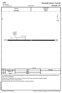
Runways:
| RWY identifier | QFU | Length (ft) | Width (ft) | Surface | LDA (ft) |
| 10 | 90° | 4208 | 75 | ASPH | |
| 28 | 270° | 4208 | 75 | ASPH |
Airport contact information
Address: Norwalk United States
Satellite view of 5A1
Sorry, we have no imagery here.
Sorry, we have no imagery here.
Sorry, we have no imagery here.
Sorry, we have no imagery here.
Sorry, we have no imagery here.