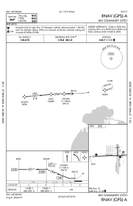
57D - Ray Community
Located in Ray, United States
ICAO - 57D, IATA -
Data provided by AirmateGeneral information
Coordinates: N42°44'12" W82°53'20"
Elevation is 632 feet MSL.
Magnetic variation is -06° East View others Airports in Michigan
Operational data
Special qualification required
Current time UTC:
Current local time:
Weather at : KMTC - Selfridge Angb ( 14 km )
METAR: KMTC 032256Z 29014KT 10SM BKN130 OVC170 14/02 A2997 RMK AO2A SLP153 T01400019 $
TAF: TAF KMTC 031900Z 0319/0501 24020G25KT 9999 FEW180 SCT250 510006 QNH2986INS BECMG 0323/0324 VRB06KT 9999 FEW100 BKN140 OVC200 QNH3005INS TX19/0319Z TN04/0412Z LAST NO AMDS AFT 0403 NEXT 0411
Communications frequencies: [VIEW]
Runways:
| RWY identifier | QFU | Length (ft) | Width (ft) | Surface | LDA (ft) |
| 01 | 359° | 2202 | 123 | OTHER | |
| 19 | 179° | 2202 | 123 | OTHER | |
| 10 | 88° | 2495 | 60 | ASPH | |
| 28 | 268° | 2495 | 60 | ASPH |
Airport contact information
Address: Ray United States
Other aviation service providers
Flight schools
Satellite view of 57D
Sorry, we have no imagery here.
Sorry, we have no imagery here.
Sorry, we have no imagery here.
Sorry, we have no imagery here.
Sorry, we have no imagery here.
Sorry, we have no imagery here.


