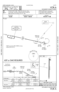
IAC chart of 56D
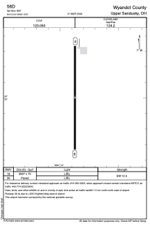
 ADC chart of 56D
 Satellite view of 56D
ADC chart of 56D
Satellite view of 56D
Sorry, we have no imagery here.
Sorry, we have no imagery here.
Sorry, we have no imagery here.
Sorry, we have no imagery here.
Sorry, we have no imagery here.
Sorry, we have no imagery here.


56D - Wyandot County
Located in Upper Sandusky, United States
ICAO - 56D, IATA -
Data provided by AirmateGeneral information
Coordinates: N40°53'0" W83°18'52"
Elevation is 830 feet MSL.
Magnetic variation is -05° East View others Airports in Ohio
Operational data
Special qualification required
Current time UTC:
Current local time:
Weather at : KFDY - Findlay ( 33 km )
METAR: KFDY 082053Z AUTO 29008KT 10SM BKN055 03/M09 A3011 RMK AO2 SLP200 T00331094 56008 $
TAF: KFDY 081725Z 0818/0918 31010KT P6SM FEW035 FM090500 VRB04KT P6SM SCT250 FM091400 18008KT P6SM BKN250
Communications frequencies: [VIEW]
Runways:
| RWY identifier | QFU | Length (ft) | Width (ft) | Surface | LDA (ft) |
| 18 | 180° | 3997 | 75 | ASPH | |
| 36 | 0° | 3997 | 75 | ASPH |
Airport contact information
Address: Upper Sandusky United States
Satellite view of 56D
Sorry, we have no imagery here.
Sorry, we have no imagery here.
Sorry, we have no imagery here.
Sorry, we have no imagery here.
Sorry, we have no imagery here.
Sorry, we have no imagery here.