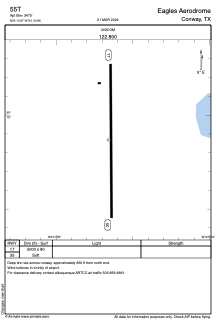
ADC chart of 55T
 Satellite view of 55T
Satellite view of 55T
Sorry, we have no imagery here.
Sorry, we have no imagery here.
Sorry, we have no imagery here.
Sorry, we have no imagery here.
Sorry, we have no imagery here.
Sorry, we have no imagery here.


55T - Eagles Aerodrome
Located in Conway, United States
ICAO - 55T, IATA -
Data provided by AirmateGeneral information
Coordinates: N35°12'52" W101°24'40"
Elevation is 3475 feet MSL.
Magnetic variation is 09° East View others Airports in Texas
Operational data
Special qualification required
Current time UTC:
Current local time:
Weather at : KAMA - Rick Husband Amarillo Intl ( 27 km )
METAR: KAMA 020153Z 20018KT 10SM CLR 22/M01 A2934 RMK AO2 SLP897 T02221011 $
TAF: KAMA 012327Z 0200/0224 24025G35KT 6SM BLDU SCT230 FM020500 26022G32KT P6SM BKN140 FM020600 28020G29KT P6SM BKN110 FM021800 27012KT P6SM FEW230
Communications frequencies: [VIEW]
Runways:
| RWY identifier | QFU | Length (ft) | Width (ft) | Surface | LDA (ft) |
| 17 | 180° | 5000 | 80 | GRASS | |
| 35 | 0° | 5000 | 80 | GRASS |
Airport contact information
Address: Conway United States
Satellite view of 55T
Sorry, we have no imagery here.
Sorry, we have no imagery here.
Sorry, we have no imagery here.
Sorry, we have no imagery here.
Sorry, we have no imagery here.
Sorry, we have no imagery here.