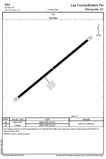
ADC chart of 52J
 Satellite view of 52J
Satellite view of 52J
Sorry, we have no imagery here.
Sorry, we have no imagery here.
Sorry, we have no imagery here.
Sorry, we have no imagery here.
Sorry, we have no imagery here.
Sorry, we have no imagery here.


52J - Lee County/Butters Fld
Located in Bishopville, United States
ICAO - 52J, IATA -
Data provided by AirmateGeneral information
Coordinates: N34°14'40" W80°14'10"
Elevation is 211 feet MSL.
Magnetic variation is -05° East View others Airports in South Carolina
Operational data
Special qualification required
Current time UTC:
Current local time:
Weather at : KHVS - Hartsville Rgnl ( 21 km )
METAR: KHVS 051355Z AUTO 21007G14KT 180V240 10SM OVC012 21/19 A3023 RMK AO2
Communications frequencies: [VIEW]
Runways:
| RWY identifier | QFU | Length (ft) | Width (ft) | Surface | LDA (ft) |
| 06 | 51° | 3200 | 60 | ASPH | |
| 24 | 231° | 3200 | 60 | ASPH |
Airport contact information
Address: Bishopville United States
Satellite view of 52J
Sorry, we have no imagery here.
Sorry, we have no imagery here.
Sorry, we have no imagery here.
Sorry, we have no imagery here.
Sorry, we have no imagery here.
Sorry, we have no imagery here.