ADC chart of 51K
 Satellite view of 51K
Satellite view of 51K
Sorry, we have no imagery here.
Sorry, we have no imagery here.
Sorry, we have no imagery here.
Sorry, we have no imagery here.
Sorry, we have no imagery here.
Sorry, we have no imagery here.


51K - Cedar Air Park
Located in Olathe, United States
ICAO - 51K, IATA -
Data provided by AirmateGeneral information
Coordinates: N38°55'52" W94°53'5"
Elevation is 1024 feet MSL.
Magnetic variation is 05° East View others Airports in Kansas
Operational data
Special qualification required
Current time UTC:
Current local time:
Weather at : KIXD - New Century Aircenter ( 11 km )
METAR: KIXD 112153Z VRB05KT 10SM CLR 18/03 A3023 RMK AO2 SLP234 T01780028
TAF: KIXD 111722Z 1118/1218 01014KT P6SM FEW035 FM120000 VRB05KT P6SM SKC FM120900 16009KT P6SM SKC FM121600 18012G20KT P6SM SKC
Communications frequencies: [VIEW]
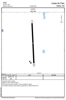
Runways:
| RWY identifier | QFU | Length (ft) | Width (ft) | Surface | LDA (ft) |
| 17 | 177° | 2440 | 75 | GRASS | |
| 35 | 357° | 2440 | 75 | GRASS |
Airport contact information
Address: Olathe United States
Satellite view of 51K
Sorry, we have no imagery here.
Sorry, we have no imagery here.
Sorry, we have no imagery here.
Sorry, we have no imagery here.
Sorry, we have no imagery here.
Sorry, we have no imagery here.