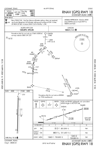
IAC chart of 50R
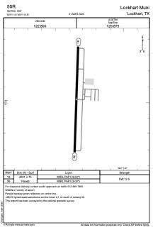
 ADC chart of 50R
 Satellite view of 50R
ADC chart of 50R
Satellite view of 50R
Sorry, we have no imagery here.
Sorry, we have no imagery here.
Sorry, we have no imagery here.
Sorry, we have no imagery here.
Sorry, we have no imagery here.
Sorry, we have no imagery here.


50R - Lockhart Muni
Located in Lockhart, United States
ICAO - 50R, IATA -
Data provided by AirmateGeneral information
Coordinates: N29°51'1" W97°40'21"
Elevation is 532 feet MSL.
Magnetic variation is 07° East View others Airports in Texas
Operational data
Special qualification required
Current time UTC:
Current local time:
Weather at : KHYI - San Marcos Rgnl ( 19 km )
METAR: KHYI 020156Z AUTO 16015KT 10SM BKN022 24/22 A2958 RMK AO2 PK WND 15026/0057 SLP012 T02390217
Communications frequencies: [VIEW]
Runways:
| RWY identifier | QFU | Length (ft) | Width (ft) | Surface | LDA (ft) |
| 18 | 182° | 4001 | 75 | ASPH | |
| 36 | 2° | 4001 | 75 | ASPH |
Airport contact information
Address: Lockhart United States
Other aviation service providers
Flight schools

Satellite view of 50R
Sorry, we have no imagery here.
Sorry, we have no imagery here.
Sorry, we have no imagery here.
Sorry, we have no imagery here.
Sorry, we have no imagery here.
Sorry, we have no imagery here.