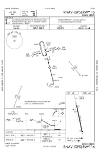
IAC chart of 4R7
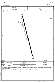
 ADC chart of 4R7
 Satellite view of 4R7
ADC chart of 4R7
Satellite view of 4R7
Sorry, we have no imagery here.
Sorry, we have no imagery here.
Sorry, we have no imagery here.
Sorry, we have no imagery here.
Sorry, we have no imagery here.
Sorry, we have no imagery here.


4R7 - Eunice
Located in Eunice, United States
ICAO - 4R7, IATA -
Data provided by AirmateGeneral information
Coordinates: N30°27'59" W92°25'26"
Elevation is 42 feet MSL.
Magnetic variation is 02° East View others Airports in Louisiana
Operational data
Special qualification required
Current time UTC:
Current local time:
Weather at : KOPL - St Landry Parish ( 33 km )
METAR: KOPL 100535Z AUTO 00000KT 10SM CLR 14/11 A3018 RMK AO2 T01350110
Communications frequencies: [VIEW]
Runways:
| RWY identifier | QFU | Length (ft) | Width (ft) | Surface | LDA (ft) |
| 16 | 166° | 5001 | 75 | ASPH | |
| 34 | 346° | 5001 | 75 | ASPH |
Airport contact information
Address: Eunice United States
Other aviation service providers
Flight schools

Satellite view of 4R7
Sorry, we have no imagery here.
Sorry, we have no imagery here.
Sorry, we have no imagery here.
Sorry, we have no imagery here.
Sorry, we have no imagery here.
Sorry, we have no imagery here.