ADC chart of 4NC4
 Satellite view of 4NC4
Satellite view of 4NC4
Sorry, we have no imagery here.
Sorry, we have no imagery here.
Sorry, we have no imagery here.
Sorry, we have no imagery here.
Sorry, we have no imagery here.
Sorry, we have no imagery here.


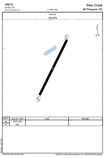
4NC4 - Bear Creek
Located in Mt Pleasant, United States
ICAO - 4NC4, IATA -
Data provided by AirmateGeneral information
Coordinates: N35°24'23" W80°21'29"
Elevation is 795 feet MSL.
Magnetic variation is -07° East View others Airports in North Carolina
Operational data
Special qualification required
Current time UTC:
Current local time:
Weather at : KVUJ - Stanly County ( 19 km )
METAR: KVUJ 012230Z AUTO 00000KT 10SM CLR 20/04 A3008 RMK AO2 T02020043
Communications frequencies: [VIEW]
Runways:
| RWY identifier | QFU | Length (ft) | Width (ft) | Surface | LDA (ft) |
| 03 | 0° | 2074 | 85 | GRASS | |
| 21 | 0° | 2074 | 85 | GRASS |
Airport contact information
Address: Mt Pleasant United States
Satellite view of 4NC4
Sorry, we have no imagery here.
Sorry, we have no imagery here.
Sorry, we have no imagery here.
Sorry, we have no imagery here.
Sorry, we have no imagery here.
Sorry, we have no imagery here.