ADC chart of 4M2
 Satellite view of 4M2
Satellite view of 4M2
Sorry, we have no imagery here.
Sorry, we have no imagery here.
Sorry, we have no imagery here.
Sorry, we have no imagery here.
Sorry, we have no imagery here.
Sorry, we have no imagery here.


4M2 - Booneville Muni
Located in Booneville, United States
ICAO - 4M2, IATA -
Data provided by AirmateGeneral information
Coordinates: N35°8'58" W93°51'48"
Elevation is 468 feet MSL.
Magnetic variation is 05° East View others Airports in Arkansas
Operational data
Special qualification required
Current time UTC:
Current local time:
Weather at : KFSM - Fort Smith Rgnl ( 50 km )
METAR: KFSM 260153Z 12004KT 10SM BKN065 BKN085 33/24 A2991 RMK AO2 SLP121 T03330239
TAF: KFSM 260157Z 2602/2624 VRB05KT P6SM VCSH BKN060 BKN250 FM260400 08003KT P6SM SCT060 BKN250 FM261500 15007KT P6SM SCT035 SCT050 BKN150
Communications frequencies: [VIEW]
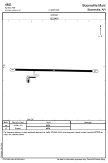
Runways:
| RWY identifier | QFU | Length (ft) | Width (ft) | Surface | LDA (ft) |
| 09 | 91° | 3254 | 50 | ASPH | |
| 27 | 271° | 3254 | 50 | ASPH |
Airport contact information
Address: Booneville United States
Satellite view of 4M2
Sorry, we have no imagery here.
Sorry, we have no imagery here.
Sorry, we have no imagery here.
Sorry, we have no imagery here.
Sorry, we have no imagery here.
Sorry, we have no imagery here.