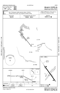
IAC chart of 4G1
 Satellite view of 4G1
Satellite view of 4G1
Sorry, we have no imagery here.
Sorry, we have no imagery here.
Sorry, we have no imagery here.
Sorry, we have no imagery here.
Sorry, we have no imagery here.
Sorry, we have no imagery here.


4G1 - Greenville Muni
Located in Greenville, United States
ICAO - 4G1, IATA -
Data provided by AirmateGeneral information
Coordinates: N41°26'48" W80°23'28"
Elevation is 1206 feet MSL.
Magnetic variation is -09° East View others Airports in Pennsylvania
Operational data
Special qualification required
Current time UTC:
Current local time:
Weather at : KGKJ - Port Meadville ( 25 km )
METAR: KGKJ 060953Z AUTO 36009G18KT 7SM OVC005 03/02 A2993 RMK AO2 RAE31 CIG 003V008 SLP140 P0000 T00280022
Communications frequencies: [VIEW]
Runways:
| RWY identifier | QFU | Length (ft) | Width (ft) | Surface | LDA (ft) |
| 05 | 41° | 2551 | 118 | GRASS | |
| 23 | 221° | 2551 | 118 | GRASS | |
| 15 | 141° | 3006 | 75 | ASPH | |
| 33 | 321° | 3006 | 75 | ASPH |
Airport contact information
Address: Greenville United States
Satellite view of 4G1
Sorry, we have no imagery here.
Sorry, we have no imagery here.
Sorry, we have no imagery here.
Sorry, we have no imagery here.
Sorry, we have no imagery here.
Sorry, we have no imagery here.