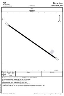
ADC chart of 4E8
 Satellite view of 4E8
Satellite view of 4E8
Sorry, we have no imagery here.
Sorry, we have no imagery here.
Sorry, we have no imagery here.
Sorry, we have no imagery here.
Sorry, we have no imagery here.
Sorry, we have no imagery here.


4E8 - Richardton
Located in Richardton, United States
ICAO - 4E8, IATA -
Data provided by AirmateGeneral information
Coordinates: N46°53'45" W102°21'24"
Elevation is 2498 feet MSL.
Magnetic variation is 11° East View others Airports in North Dakota
Operational data
Special qualification required
Current time UTC:
Current local time:
Weather at : KDIK - Dickinson/Theodore Roosevelt Rgnl ( 36 km )
METAR: KDIK 021156Z AUTO 27006KT 7SM CLR 11/09 A3013 RMK AO2 SLP194 T01110094 10161 20111 51003
TAF: KDIK 021137Z 0212/0312 31005KT P6SM FEW150 FM021700 35009KT 6SM FU SCT100 PROB30 0300/0306 5SM -SHRA BR OVC060 FM030600 01009KT 6SM FU BKN060
Communications frequencies: [VIEW]
Runways:
| RWY identifier | QFU | Length (ft) | Width (ft) | Surface | LDA (ft) |
| 11 | 125° | 3822 | 110 | GRASS | |
| 29 | 305° | 3822 | 110 | GRASS |
Airport contact information
Address: Richardton United States
Satellite view of 4E8
Sorry, we have no imagery here.
Sorry, we have no imagery here.
Sorry, we have no imagery here.
Sorry, we have no imagery here.
Sorry, we have no imagery here.
Sorry, we have no imagery here.