IAC chart of 4D8
 ADC chart of 4D8
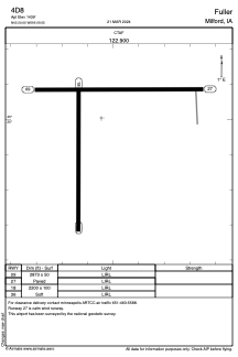
 Satellite view of 4D8
ADC chart of 4D8
Satellite view of 4D8
Sorry, we have no imagery here.
Sorry, we have no imagery here.
Sorry, we have no imagery here.
Sorry, we have no imagery here.
Sorry, we have no imagery here.
Sorry, we have no imagery here.


4D8 - Fuller
Located in Milford, United States
ICAO - 4D8, IATA -
Data provided by AirmateGeneral information
Coordinates: N43°20'0" W95°9'33"
Elevation is 1439 feet MSL.
Magnetic variation is 05° East View others Airports in Iowa
Operational data
Special qualification required
Current time UTC:
Current local time:
Weather at : KSPW - Spencer Muni ( 19 km )
METAR: KSPW 022053Z AUTO 27020G29KT 10SM OVC012 07/03 A2932 RMK AO2 PK WND 26031/2013 SLP934 T00670033 52033
Communications frequencies: [VIEW]
Runways:
| RWY identifier | QFU | Length (ft) | Width (ft) | Surface | LDA (ft) |
| 09 | 90° | 2873 | 50 | ASPH | |
| 27 | 270° | 2873 | 50 | ASPH | |
| 18 | 180° | 2200 | 100 | GRASS | |
| 36 | 0° | 2200 | 100 | GRASS |
Airport contact information
Address: Milford United States
Satellite view of 4D8
Sorry, we have no imagery here.
Sorry, we have no imagery here.
Sorry, we have no imagery here.
Sorry, we have no imagery here.
Sorry, we have no imagery here.
Sorry, we have no imagery here.