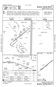
IAC chart of 4A5
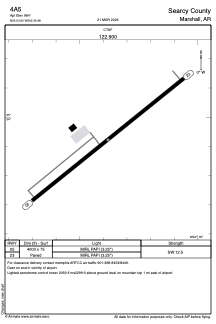
 ADC chart of 4A5
 Satellite view of 4A5
ADC chart of 4A5
Satellite view of 4A5
Sorry, we have no imagery here.
Sorry, we have no imagery here.
Sorry, we have no imagery here.
Sorry, we have no imagery here.
Sorry, we have no imagery here.
Sorry, we have no imagery here.


4A5 - Searcy County
Located in Marshall, United States
ICAO - 4A5, IATA -
Data provided by AirmateGeneral information
Coordinates: N35°53'55" W92°39'23"
Elevation is 964 feet MSL.
Magnetic variation is 00° East View others Airports in Arkansas
Operational data
Special qualification required
Current time UTC:
Current local time:
Weather at : KCCA - Clinton Muni ( 38 km )
METAR: KCCA 110735Z AUTO 00000KT 10SM FEW050 22/21 A3007 RMK AO2
Communications frequencies: [VIEW]
Runways:
| RWY identifier | QFU | Length (ft) | Width (ft) | Surface | LDA (ft) |
| 05 | 51° | 4003 | 75 | ASPH | |
| 23 | 231° | 4003 | 75 | ASPH |
Airport contact information
Address: Marshall United States
Satellite view of 4A5
Sorry, we have no imagery here.
Sorry, we have no imagery here.
Sorry, we have no imagery here.
Sorry, we have no imagery here.
Sorry, we have no imagery here.
Sorry, we have no imagery here.