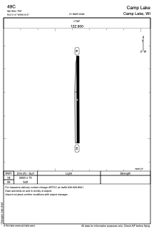
ADC chart of 49C
 Satellite view of 49C
Satellite view of 49C
Sorry, we have no imagery here.
Sorry, we have no imagery here.
Sorry, we have no imagery here.
Sorry, we have no imagery here.
Sorry, we have no imagery here.
Sorry, we have no imagery here.


49C - Camp Lake
Located in Camp Lake, United States
ICAO - 49C, IATA -
Data provided by AirmateGeneral information
Coordinates: N42°31'40" W88°9'22"
Elevation is 755 feet MSL.
Magnetic variation is -01° East View others Airports in Wisconsin
Operational data
Special qualification required
Current time UTC:
Current local time:
Weather at : KENW - Kenosha Rgnl ( 20 km )
METAR: KENW 210553Z AUTO 06011KT 4SM BR OVC007 09/07 A2972 RMK AO2 RAB07E16 SLP065 P0000 60018 T00890067 10089 20083 401060078 57007
TAF: KENW 210520Z 2106/2206 07012KT P6SM OVC006 TEMPO 2106/2109 5SM -SHRA BR OVC004 FM210900 06012KT 4SM BR OVC003 TEMPO 2109/2110 -SHRA FM211000 06012KT 4SM -SHRA OVC003 FM211500 02011KT 5SM -SHRA OVC003
Communications frequencies: [VIEW]
Runways:
| RWY identifier | QFU | Length (ft) | Width (ft) | Surface | LDA (ft) |
| 18 | 0° | 2260 | 75 | GRASS | |
| 36 | 0° | 2260 | 75 | GRASS |
Airport contact information
Address: Camp Lake United States
Satellite view of 49C
Sorry, we have no imagery here.
Sorry, we have no imagery here.
Sorry, we have no imagery here.
Sorry, we have no imagery here.
Sorry, we have no imagery here.
Sorry, we have no imagery here.