ADC chart of 45K
 Satellite view of 45K
Satellite view of 45K
Sorry, we have no imagery here.
Sorry, we have no imagery here.
Sorry, we have no imagery here.
Sorry, we have no imagery here.
Sorry, we have no imagery here.
Sorry, we have no imagery here.


45K - Minneapolis City County
Located in Minneapolis, United States
ICAO - 45K, IATA -
Data provided by AirmateGeneral information
Coordinates: N39°5'40" W97°43'16"
Elevation is 1246 feet MSL.
Magnetic variation is 07° East View others Airports in Kansas
Operational data
Special qualification required
Current time UTC:
Current local time:
Weather at : KSLN - Salina Rgnl ( 34 km )
METAR: KSLN 111153Z 29006KT 10SM CLR 04/M02 A3031 RMK AO2 SLP265 T00441017 10089 20044 53014
TAF: KSLN 111120Z 1112/1212 34006KT P6SM SKC FM111900 14006KT P6SM SKC FM120900 17011KT P6SM SKC WS015/20030KT
Communications frequencies: [VIEW]
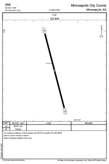
Runways:
| RWY identifier | QFU | Length (ft) | Width (ft) | Surface | LDA (ft) |
| 16 | 165° | 3970 | 20 | ASPH | |
| 34 | 345° | 3970 | 20 | ASPH |
Airport contact information
Address: Minneapolis United States
Satellite view of 45K
Sorry, we have no imagery here.
Sorry, we have no imagery here.
Sorry, we have no imagery here.
Sorry, we have no imagery here.
Sorry, we have no imagery here.
Sorry, we have no imagery here.