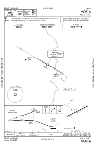
IAC chart of 44C
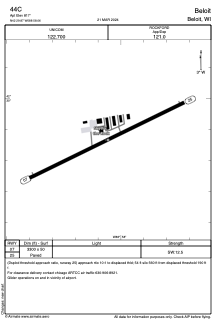
 ADC chart of 44C
 Satellite view of 44C
ADC chart of 44C
Satellite view of 44C
Sorry, we have no imagery here.
Sorry, we have no imagery here.
Sorry, we have no imagery here.
Sorry, we have no imagery here.
Sorry, we have no imagery here.


44C - Beloit
Located in Beloit, United States
ICAO - 44C, IATA -
Data provided by AirmateGeneral information
Coordinates: N42°29'52" W88°58'3"
Elevation is 817 feet MSL.
Magnetic variation is -03° East View others Airports in Wisconsin
Operational data
Special qualification required
Current time UTC:
Current local time:
Weather at : KJVL - Southern Wisconsin Rgnl ( 15 km )
METAR: KJVL 201545Z 09014G18KT 2SM -RA OVC008 07/07 A2975
TAF: KJVL 201437Z 2015/2112 09021G35KT 5SM -SHRA OVC008 FM210000 08018G28KT P6SM OVC006 PROB30 2100/2104 4SM -SHRA FM210400 08016G26KT 3SM -SHRA OVC005
Communications frequencies: [VIEW]
Runways:
| RWY identifier | QFU | Length (ft) | Width (ft) | Surface | LDA (ft) |
| 07 | 64° | 3300 | 50 | ASPH | |
| 25 | 244° | 3300 | 50 | ASPH |
Airport contact information
Address: Beloit United States
Satellite view of 44C
Sorry, we have no imagery here.
Sorry, we have no imagery here.
Sorry, we have no imagery here.
Sorry, we have no imagery here.
Sorry, we have no imagery here.