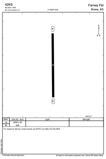
ADC chart of 42KS
 Satellite view of 42KS
Satellite view of 42KS
Sorry, we have no imagery here.
Sorry, we have no imagery here.
Sorry, we have no imagery here.
Sorry, we have no imagery here.
Sorry, we have no imagery here.
Sorry, we have no imagery here.


42KS - Farney Fld
Located in Kiowa, United States
ICAO - 42KS, IATA -
Data provided by AirmateGeneral information
Coordinates: N37°0'38" W98°27'16"
Elevation is 1349 feet MSL.
View others Airports in Kansas
Operational data
Special qualification required
Current time UTC:
Current local time:
Weather at : KAVK - Alva Rgnl ( 33 km )
METAR: KAVK 112015Z AUTO 15007G13KT 10SM CLR 23/01 A3024 RMK AO2
Communications frequencies: [VIEW]
Runways:
| RWY identifier | QFU | Length (ft) | Width (ft) | Surface | LDA (ft) |
| 18 | 0° | 2339 | 30 | GRASS | |
| 36 | 0° | 2339 | 30 | GRASS |
Airport contact information
Address: Kiowa United States
Satellite view of 42KS
Sorry, we have no imagery here.
Sorry, we have no imagery here.
Sorry, we have no imagery here.
Sorry, we have no imagery here.
Sorry, we have no imagery here.
Sorry, we have no imagery here.