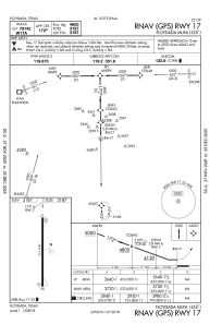
IAC chart of 41F
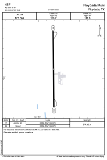
 ADC chart of 41F
 Satellite view of 41F
ADC chart of 41F
Satellite view of 41F
Sorry, we have no imagery here.
Sorry, we have no imagery here.
Sorry, we have no imagery here.
Sorry, we have no imagery here.
Sorry, we have no imagery here.
Sorry, we have no imagery here.


41F - Floydada Muni
Located in Floydada, United States
ICAO - 41F, IATA -
Data provided by AirmateGeneral information
Coordinates: N34°0'6" W101°19'49"
Elevation is 3187 feet MSL.
Magnetic variation is 07° East View others Airports in Texas
Operational data
Special qualification required
Current time UTC:
Current local time:
Weather at : KPVW - Hale County ( 40 km )
METAR: KPVW 020130Z AUTO 23018G29KT 7SM CLR 24/M03 A2940 RMK AO2 T02361028 TSNO
TAF: KPVW 012320Z 0200/0224 24022G32KT P6SM FEW250 FM020300 25020KT P6SM SCT250 FM021200 29011KT P6SM SKC FM021600 27016G26KT P6SM FEW100
Communications frequencies: [VIEW]
Runways:
| RWY identifier | QFU | Length (ft) | Width (ft) | Surface | LDA (ft) |
| 17 | 179° | 4600 | 60 | ASPH | |
| 35 | 359° | 4600 | 60 | ASPH |
Airport contact information
Address: Floydada United States
Satellite view of 41F
Sorry, we have no imagery here.
Sorry, we have no imagery here.
Sorry, we have no imagery here.
Sorry, we have no imagery here.
Sorry, we have no imagery here.
Sorry, we have no imagery here.