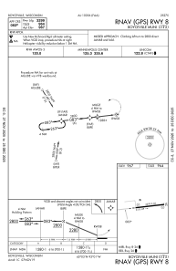
IAC chart of 3T3
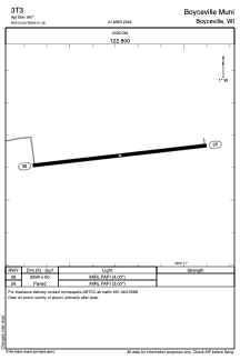
 ADC chart of 3T3
 Satellite view of 3T3
ADC chart of 3T3
Satellite view of 3T3
Sorry, we have no imagery here.
Sorry, we have no imagery here.
Sorry, we have no imagery here.
Sorry, we have no imagery here.
Sorry, we have no imagery here.
Sorry, we have no imagery here.


3T3 - Boyceville Muni
Located in Boyceville, United States
ICAO - 3T3, IATA -
Data provided by AirmateGeneral information
Coordinates: N45°2'38" W92°1'17"
Elevation is 967 feet MSL.
Magnetic variation is 00° East View others Airports in Wisconsin
Operational data
Special qualification required
Current time UTC:
Current local time:
Weather at : KLUM - Menomonie Muni/Score Fld ( 21 km )
METAR: KLUM 221715Z AUTO 36013KT 10SM SCT050 16/03 A3008 RMK AO2 T01580033 PWINO
Communications frequencies: [VIEW]
Runways:
| RWY identifier | QFU | Length (ft) | Width (ft) | Surface | LDA (ft) |
| 08 | 84° | 3299 | 60 | ASPH | |
| 26 | 264° | 3299 | 60 | ASPH |
Airport contact information
Address: Boyceville United States
Satellite view of 3T3
Sorry, we have no imagery here.
Sorry, we have no imagery here.
Sorry, we have no imagery here.
Sorry, we have no imagery here.
Sorry, we have no imagery here.
Sorry, we have no imagery here.