ADC chart of 38C
 Satellite view of 38C
Satellite view of 38C
Sorry, we have no imagery here.
Sorry, we have no imagery here.
Sorry, we have no imagery here.
Sorry, we have no imagery here.
Sorry, we have no imagery here.
Sorry, we have no imagery here.


38C - Cain Fld
Located in Stanwood, United States
ICAO - 38C, IATA -
Data provided by AirmateGeneral information
Coordinates: N43°35'54" W85°29'33"
Elevation is 897 feet MSL.
Magnetic variation is -04° East View others Airports in Michigan
Operational data
Special qualification required
Current time UTC:
Current local time:
Weather at : KRQB - Roben-Hood ( 14 km )
METAR: KRQB 022135Z AUTO 13013KT 10SM OVC006 03/02 A2957 RMK AO2 T00250020
Communications frequencies: [VIEW]
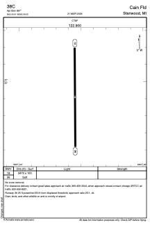
Runways:
| RWY identifier | QFU | Length (ft) | Width (ft) | Surface | LDA (ft) |
| 18 | 180° | 3472 | 100 | GRASS | |
| 36 | 360° | 3472 | 100 | GRASS |
Airport contact information
Address: Stanwood United States
Satellite view of 38C
Sorry, we have no imagery here.
Sorry, we have no imagery here.
Sorry, we have no imagery here.
Sorry, we have no imagery here.
Sorry, we have no imagery here.
Sorry, we have no imagery here.