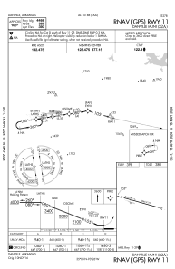
IAC chart of 32A
 Satellite view of 32A
Satellite view of 32A
Sorry, we have no imagery here.
Sorry, we have no imagery here.
Sorry, we have no imagery here.
Sorry, we have no imagery here.
Sorry, we have no imagery here.
Sorry, we have no imagery here.


32A - Danville Muni
Located in Danville, United States
ICAO - 32A, IATA -
Data provided by AirmateGeneral information
Coordinates: N35°5'14" W93°25'44"
Elevation is 393 feet MSL.
Magnetic variation is 01° East View others Airports in Arkansas
Operational data
Special qualification required
Current time UTC:
Current local time:
Weather at : KRUE - Russellville Rgnl ( 36 km )
METAR: KRUE 051100Z AUTO 05012G18KT 5SM +TSRA OVC021 13/10 A2987 RMK AO2 LTG DSNT ALQDS TSB00 P0003 T01280100
Communications frequencies: [VIEW]
Runways:
| RWY identifier | QFU | Length (ft) | Width (ft) | Surface | LDA (ft) |
| 11 | 106° | 4466 | 75 | ASPH | |
| 29 | 286° | 4466 | 75 | ASPH |
Airport contact information
Address: Danville United States
Satellite view of 32A
Sorry, we have no imagery here.
Sorry, we have no imagery here.
Sorry, we have no imagery here.
Sorry, we have no imagery here.
Sorry, we have no imagery here.
Sorry, we have no imagery here.