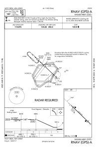
IAC chart of 31E
 ADC chart of 31E
 Satellite view of 31E
ADC chart of 31E
Satellite view of 31E
Sorry, we have no imagery here.
Sorry, we have no imagery here.
Sorry, we have no imagery here.
Sorry, we have no imagery here.
Sorry, we have no imagery here.
Sorry, we have no imagery here.


31E - Eagles Nest
Located in West Creek, United States
ICAO - 31E, IATA -
Data provided by AirmateGeneral information
Coordinates: N39°39'56" W74°18'29"
Elevation is 39 feet MSL.
Magnetic variation is -12° East View others Airports in New Jersey
Operational data
Special qualification required
Current time UTC:
Current local time:
Weather at : KMJX - Ocean County ( 29 km )
METAR: KMJX 050456Z AUTO 00000KT 10SM SCT080 11/08 A3029 RMK AO2 SLP259 T01110083 402170100
Communications frequencies: [VIEW]
Runways:
| RWY identifier | QFU | Length (ft) | Width (ft) | Surface | LDA (ft) |
| 14 | 134° | 3670 | 60 | ASPH | |
| 32 | 314° | 3670 | 60 | ASPH |
Airport contact information
Address: West Creek United States
Satellite view of 31E
Sorry, we have no imagery here.
Sorry, we have no imagery here.
Sorry, we have no imagery here.
Sorry, we have no imagery here.
Sorry, we have no imagery here.
Sorry, we have no imagery here.