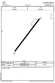
ADC chart of 2R1
 Satellite view of 2R1
Satellite view of 2R1
Sorry, we have no imagery here.
Sorry, we have no imagery here.
Sorry, we have no imagery here.
Sorry, we have no imagery here.
Sorry, we have no imagery here.
Sorry, we have no imagery here.


2R1 - Le Maire Meml
Located in Jeanerette, United States
ICAO - 2R1, IATA -
Data provided by AirmateGeneral information
Coordinates: N29°53'57" W91°39'58"
Elevation is 14 feet MSL.
Magnetic variation is 04° East View others Airports in Louisiana
Operational data
Special qualification required
Current time UTC:
Current local time:
Weather at : KARA - Acadiana Rgnl ( 26 km )
METAR: KARA 061553Z 34010KT 10SM OVC014 17/13 A2992 RMK AO2 SLP130 T01720133
TAF: KARA 061504Z 0615/0712 33015G23KT P6SM VCSH OVC015 FM070000 33012KT P6SM BKN025 FM070600 36010KT P6SM BKN025
Communications frequencies: [VIEW]
Runways:
| RWY identifier | QFU | Length (ft) | Width (ft) | Surface | LDA (ft) |
| 04 | 37° | 3000 | 75 | ASPH | |
| 22 | 217° | 3000 | 75 | ASPH |
Airport contact information
Address: Jeanerette United States
Satellite view of 2R1
Sorry, we have no imagery here.
Sorry, we have no imagery here.
Sorry, we have no imagery here.
Sorry, we have no imagery here.
Sorry, we have no imagery here.
Sorry, we have no imagery here.