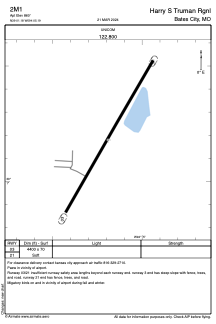
ADC chart of 2M1
 Satellite view of 2M1
Satellite view of 2M1
Sorry, we have no imagery here.
Sorry, we have no imagery here.
Sorry, we have no imagery here.
Sorry, we have no imagery here.
Sorry, we have no imagery here.


2M1 - Harry S Truman Rgnl
Located in Bates City, United States
ICAO - 2M1, IATA -
Data provided by AirmateGeneral information
Coordinates: N39°1'11" W94°5'11"
Elevation is 860 feet MSL.
Magnetic variation is 05° East View others Airports in Missouri
Operational data
Special qualification required
Current time UTC:
Current local time:
Weather at : KLXT - Lee's Summit Muni ( 26 km )
METAR: KLXT 131753Z AUTO 10SM FEW042 30/18 A3004 RMK AO2 SLP161 T03000183 10300 20200 58005 $
Communications frequencies: [VIEW]
Runways:
| RWY identifier | QFU | Length (ft) | Width (ft) | Surface | LDA (ft) |
| 03 | 0° | 4400 | 70 | GRAVEL | |
| 21 | 0° | 4400 | 70 | GRAVEL |
Airport contact information
Address: Bates City United States
Satellite view of 2M1
Sorry, we have no imagery here.
Sorry, we have no imagery here.
Sorry, we have no imagery here.
Sorry, we have no imagery here.
Sorry, we have no imagery here.