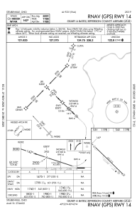
IAC chart of 2G2
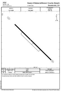
 ADC chart of 2G2
 Satellite view of 2G2
ADC chart of 2G2
Satellite view of 2G2
Sorry, we have no imagery here.
Sorry, we have no imagery here.
Sorry, we have no imagery here.
Sorry, we have no imagery here.
Sorry, we have no imagery here.
Sorry, we have no imagery here.


2G2 - Geary A Bates/Jefferson County Airpark
Located in Steubenville, United States
ICAO - 2G2, IATA -
Data provided by AirmateGeneral information
Coordinates: N40°21'38" W80°42'6"
Elevation is 1198 feet MSL.
Magnetic variation is -08° East View others Airports in Ohio
Operational data
Special qualification required
Current time UTC:
Current local time:
Weather at : KHLG - Wheeling Ohio County ( 21 km )
METAR: KHLG 061853Z 33007KT 6SM HZ SCT013 OVC049 04/01 A2999 RMK AO2 SLP163 T00390006
TAF: KHLG 061720Z 0618/0718 36008KT P6SM VCSH BKN050 TEMPO 0618/0620 BKN015 FM070400 01007KT 4SM -SNRA BKN020 TEMPO 0708/0712 2SM -SN BKN008 FM071200 36004KT P6SM BKN015 FM071600 30007KT P6SM BKN035
Communications frequencies: [VIEW]
Runways:
| RWY identifier | QFU | Length (ft) | Width (ft) | Surface | LDA (ft) |
| 14 | 134° | 5001 | 75 | ASPH | |
| 32 | 314° | 5001 | 75 | ASPH |
Airport contact information
Address: Steubenville United States
Other aviation service providers
Flight schools

Satellite view of 2G2
Sorry, we have no imagery here.
Sorry, we have no imagery here.
Sorry, we have no imagery here.
Sorry, we have no imagery here.
Sorry, we have no imagery here.
Sorry, we have no imagery here.