ADC chart of 2E7
 Satellite view of 2E7
Satellite view of 2E7
Sorry, we have no imagery here.
Sorry, we have no imagery here.
Sorry, we have no imagery here.
Sorry, we have no imagery here.
Sorry, we have no imagery here.
Sorry, we have no imagery here.


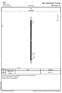
2E7 - Mc Lean/Gray County
Located in Mc Lean, United States
ICAO - 2E7, IATA -
Data provided by AirmateGeneral information
Coordinates: N35°14'49" W100°32'49"
Elevation is 2835 feet MSL.
Magnetic variation is 08° East View others Airports in Texas
Operational data
Special qualification required
Current time UTC:
Current local time:
Weather at : KPPA - Perry Lefors Fld ( 58 km )
METAR: KPPA 011815Z AUTO 20018G23KT 10SM CLR 25/03 A2950 RMK AO2 T02500025
Communications frequencies: [VIEW]
Runways:
| RWY identifier | QFU | Length (ft) | Width (ft) | Surface | LDA (ft) |
| 17 | 180° | 3225 | 50 | ASPH | |
| 35 | 360° | 3225 | 50 | ASPH |
Airport contact information
Address: Mc Lean United States
Satellite view of 2E7
Sorry, we have no imagery here.
Sorry, we have no imagery here.
Sorry, we have no imagery here.
Sorry, we have no imagery here.
Sorry, we have no imagery here.
Sorry, we have no imagery here.