ADC chart of 2D1
 Satellite view of 2D1
Satellite view of 2D1
Sorry, we have no imagery here.
Sorry, we have no imagery here.
Sorry, we have no imagery here.
Sorry, we have no imagery here.
Sorry, we have no imagery here.
Sorry, we have no imagery here.


2D1 - Lee Fld
Located in Alliance, United States
ICAO - 2D1, IATA -
Data provided by AirmateGeneral information
Coordinates: N40°58'12" W81°5'55"
Elevation is 1062 feet MSL.
Magnetic variation is -07° East View others Airports in Ohio
Operational data
Special qualification required
Current time UTC:
Current local time:
Weather at : KCAK - Akron-Canton Rgnl ( 30 km )
METAR: KCAK 091151Z 16003KT 10SM FEW080 FEW250 M03/M05 A3022 RMK AO2 SLP248 T10281050 11017 21039 51014
TAF: KCAK 091126Z 0912/1012 19003KT P6SM FEW080 FM092300 17005KT 5SM -RA OVC045 FM100200 14005KT 3SM -RA BR OVC012 FM100300 13005KT 3SM -RA BR OVC008 FM100800 13010KT 6SM -RA OVC011 FM101100 14010KT 4SM -RA BR OVC008
Communications frequencies: [VIEW]
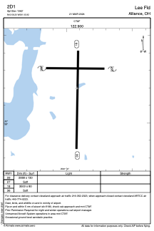
Runways:
| RWY identifier | QFU | Length (ft) | Width (ft) | Surface | LDA (ft) |
| 09 | 0° | 2088 | 130 | GRASS | |
| 27 | 0° | 2088 | 130 | GRASS | |
| 18 | 0° | 3500 | 80 | GRASS | |
| 36 | 0° | 3500 | 80 | GRASS |
Airport contact information
Address: Alliance United States
Satellite view of 2D1
Sorry, we have no imagery here.
Sorry, we have no imagery here.
Sorry, we have no imagery here.
Sorry, we have no imagery here.
Sorry, we have no imagery here.
Sorry, we have no imagery here.