ADC chart of 28M
 Satellite view of 28M

Satellite view of 28M
Sorry, we have no imagery here.
Sorry, we have no imagery here.
Sorry, we have no imagery here.
Sorry, we have no imagery here.
Sorry, we have no imagery here.
Sorry, we have no imagery here.


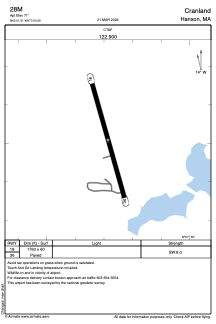
28M - Cranland
Located in Hanson, United States
ICAO - 28M, IATA -
Data provided by AirmateGeneral information
Coordinates: N42°1'31" W70°50'17"
Elevation is 71 feet MSL.
Magnetic variation is -16° East View others Airports in Massachusetts
Operational data
Special qualification required
Current time UTC:
Current local time:
Weather at : KGHG - Marshfield Muni - George Harlow Fld ( 16 km )
METAR: KGHG 280655Z AUTO 00000KT 2 1/2SM BR OVC002 21/20 A2990 RMK AO2
Communications frequencies: [VIEW]
Runways:
| RWY identifier | QFU | Length (ft) | Width (ft) | Surface | LDA (ft) |
| 18 | 0° | 1760 | 60 | ASPH | |
| 36 | 0° | 1760 | 60 | ASPH |
Airport contact information
Address: Hanson United States
Satellite view of 28M
Sorry, we have no imagery here.
Sorry, we have no imagery here.
Sorry, we have no imagery here.
Sorry, we have no imagery here.
Sorry, we have no imagery here.
Sorry, we have no imagery here.