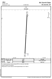
ADC chart of 26U
 Satellite view of 26U
Satellite view of 26U
Sorry, we have no imagery here.
Sorry, we have no imagery here.
Sorry, we have no imagery here.
Sorry, we have no imagery here.
Sorry, we have no imagery here.
Sorry, we have no imagery here.


26U - Mc Dermitt State
Located in Mc Dermitt, United States
ICAO - 26U, IATA -
Data provided by AirmateGeneral information
Coordinates: N42°0'37" W117°43'38"
Elevation is 4478 feet MSL.
Magnetic variation is 17° East View others Airports in Oregon
Operational data
Special qualification required
Current time UTC:
Current local time:
Weather at : KREO - Rome State ( 64 km )
METAR: KREO 110852Z AUTO 20008KT 15/01 A3017 RMK AO1 SLP180 T01500011 50002
Communications frequencies: [VIEW]
Runways:
| RWY identifier | QFU | Length (ft) | Width (ft) | Surface | LDA (ft) |
| 16 | 183° | 5900 | 60 | ASPH | |
| 34 | 3° | 5900 | 60 | ASPH |
Airport contact information
Address: Mc Dermitt United States
Satellite view of 26U
Sorry, we have no imagery here.
Sorry, we have no imagery here.
Sorry, we have no imagery here.
Sorry, we have no imagery here.
Sorry, we have no imagery here.
Sorry, we have no imagery here.