ADC chart of 26A
 Satellite view of 26A
Satellite view of 26A
Sorry, we have no imagery here.
Sorry, we have no imagery here.
Sorry, we have no imagery here.
Sorry, we have no imagery here.
Sorry, we have no imagery here.
Sorry, we have no imagery here.


26A - Ashland/Lineville
Located in Ashland/Lineville, United States
ICAO - 26A, IATA -
Data provided by AirmateGeneral information
Coordinates: N33°17'3" W85°48'32"
Elevation is 1065 feet MSL.
Magnetic variation is -01° East View others Airports in Alabama
Operational data
Special qualification required
Current time UTC:
Current local time:
Weather at : KANB - Anniston Rgnl ( 34 km )
METAR: KANB 050553Z AUTO 23003KT 10SM CLR 23/18 A3014 RMK AO2 SLP199 T02280178 10267 20228 403000194 50008
Communications frequencies: [VIEW]
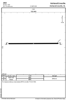
Runways:
| RWY identifier | QFU | Length (ft) | Width (ft) | Surface | LDA (ft) |
| 09 | 0° | 4023 | 80 | ASPH | |
| 27 | 0° | 4023 | 80 | ASPH |
Airport contact information
Address: Ashland/Lineville United States
Satellite view of 26A
Sorry, we have no imagery here.
Sorry, we have no imagery here.
Sorry, we have no imagery here.
Sorry, we have no imagery here.
Sorry, we have no imagery here.
Sorry, we have no imagery here.