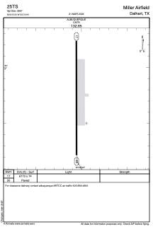
ADC chart of 25TS
 Satellite view of 25TS
Satellite view of 25TS
Sorry, we have no imagery here.
Sorry, we have no imagery here.
Sorry, we have no imagery here.
Sorry, we have no imagery here.
Sorry, we have no imagery here.


25TS - Miller Airfield
Located in Dalhart, United States
ICAO - 25TS, IATA -
Data provided by AirmateGeneral information
Coordinates: N36°5'30" W102°24'57"
Elevation is 3961 feet MSL.
Magnetic variation is 10° East View others Airports in Texas
Operational data
Special qualification required
Current time UTC:
Current local time:
Weather at : KDHT - Dalhart Muni ( 14 km )
METAR: KDHT 012053Z AUTO 23029G45KT 10SM SCT100 26/M01 A2936 RMK AO2 PK WND 23048/2001 SLP892 T02611011 58030
TAF: KDHT 011720Z 0118/0218 24033G40KT P6SM BKN250 TEMPO 0121/0124 24035G49KT 4SM BLDU BKN026 FM020200 27023G34KT 6SM BR SCT220 FM020400 29016KT P6SM FEW210
Communications frequencies: [VIEW]
Runways:
| RWY identifier | QFU | Length (ft) | Width (ft) | Surface | LDA (ft) |
| 17 | 180° | 6173 | 74 | CONC | |
| 35 | 360° | 6173 | 74 | CONC |
Airport contact information
Address: Dalhart United States
Satellite view of 25TS
Sorry, we have no imagery here.
Sorry, we have no imagery here.
Sorry, we have no imagery here.
Sorry, we have no imagery here.
Sorry, we have no imagery here.