ADC chart of 24F
 Satellite view of 24F
Satellite view of 24F
Sorry, we have no imagery here.
Sorry, we have no imagery here.
Sorry, we have no imagery here.
Sorry, we have no imagery here.
Sorry, we have no imagery here.
Sorry, we have no imagery here.


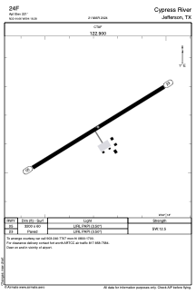
24F - Cypress River
Located in Jefferson, United States
ICAO - 24F, IATA -
Data provided by AirmateGeneral information
Coordinates: N32°44'40" W94°18'17"
Elevation is 221 feet MSL.
Magnetic variation is 05° East View others Airports in Texas
Operational data
Special qualification required
Current time UTC:
Current local time:
Weather at : KASL - Harrison County ( 25 km )
METAR: KASL 020855Z AUTO 17012G21KT 10SM CLR 23/20 A2959 RMK AO2 T02290205 58014
Communications frequencies: [VIEW]
Runways:
| RWY identifier | QFU | Length (ft) | Width (ft) | Surface | LDA (ft) |
| 05 | 59° | 3200 | 60 | ASPH | |
| 23 | 239° | 3200 | 60 | ASPH |
Airport contact information
Address: Jefferson United States
Satellite view of 24F
Sorry, we have no imagery here.
Sorry, we have no imagery here.
Sorry, we have no imagery here.
Sorry, we have no imagery here.
Sorry, we have no imagery here.
Sorry, we have no imagery here.