ADC chart of 22D
 Satellite view of 22D
Satellite view of 22D
Sorry, we have no imagery here.
Sorry, we have no imagery here.
Sorry, we have no imagery here.
Sorry, we have no imagery here.
Sorry, we have no imagery here.
Sorry, we have no imagery here.


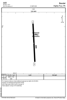
22D - Bandel
Located in Eighty Four, United States
ICAO - 22D, IATA -
Data provided by AirmateGeneral information
Coordinates: N40°7'50" W80°5'46"
Elevation is 1210 feet MSL.
Magnetic variation is -07° East View others Airports in Pennsylvania
Operational data
Special qualification required
Current time UTC:
Current local time:
Weather at : KAFJ - Washington County ( 16 km )
METAR: KAFJ 081320Z AUTO 32008G18KT 9SM -SN SCT025 BKN030 OVC041 M03/M06 A3002 RMK AO2 P0000 FZRANO $
Communications frequencies: [VIEW]
Runways:
| RWY identifier | QFU | Length (ft) | Width (ft) | Surface | LDA (ft) |
| 01 | 358° | 2260 | 100 | OTHER | |
| 19 | 178° | 2260 | 100 | OTHER |
Airport contact information
Address: Eighty Four United States
Satellite view of 22D
Sorry, we have no imagery here.
Sorry, we have no imagery here.
Sorry, we have no imagery here.
Sorry, we have no imagery here.
Sorry, we have no imagery here.
Sorry, we have no imagery here.