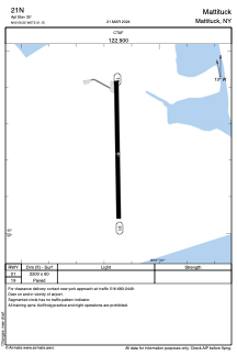
ADC chart of 21N
 Satellite view of 21N
Satellite view of 21N
Sorry, we have no imagery here.
Sorry, we have no imagery here.
Sorry, we have no imagery here.
Sorry, we have no imagery here.
Sorry, we have no imagery here.
Sorry, we have no imagery here.


21N - Mattituck
Located in Mattituck, United States
ICAO - 21N, IATA -
Data provided by AirmateGeneral information
Coordinates: N40°59'13" W72°31'9"
Elevation is 30 feet MSL.
Magnetic variation is -14° East View others Airports in New York
Operational data
Special qualification required
Current time UTC:
Current local time:
Weather at : KFOK - Francis S Gabreski ( 19 km )
METAR: KFOK 081753Z 30022G35KT 250V330 10SM FEW055 07/M08 A2965 RMK AO2 PK WND 29035/1750 SLP042 60001 T00721078 10083 20056 53009
Communications frequencies: [VIEW]
Runways:
| RWY identifier | QFU | Length (ft) | Width (ft) | Surface | LDA (ft) |
| 01 | 359° | 2200 | 60 | ASPH | |
| 19 | 179° | 2200 | 60 | ASPH |
Airport contact information
Address: Mattituck United States
Satellite view of 21N
Sorry, we have no imagery here.
Sorry, we have no imagery here.
Sorry, we have no imagery here.
Sorry, we have no imagery here.
Sorry, we have no imagery here.
Sorry, we have no imagery here.