ADC chart of 1L9
 Satellite view of 1L9
Satellite view of 1L9
Sorry, we have no imagery here.
Sorry, we have no imagery here.
Sorry, we have no imagery here.
Sorry, we have no imagery here.
Sorry, we have no imagery here.
Sorry, we have no imagery here.


1L9 - Parowan
Located in Parowan, United States
ICAO - 1L9, IATA -
Data provided by AirmateGeneral information
Coordinates: N37°51'35" W112°48'57"
Elevation is 5930 feet MSL.
Magnetic variation is 14° East View others Airports in Utah
Operational data
Special qualification required
Current time UTC:
Current local time:
Weather at : KCDC - Cedar City Rgnl ( 30 km )
METAR: KCDC 230853Z AUTO 15006KT 10SM CLR 18/03 A3012 RMK AO2 SLP115 T01830028 50002
TAF: KCDC 230558Z 2306/2406 16010KT P6SM SKC FM231800 22011G19KT P6SM SKC
Communications frequencies: [VIEW]
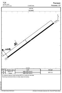
Runways:
| RWY identifier | QFU | Length (ft) | Width (ft) | Surface | LDA (ft) |
| 04 | 53° | 5000 | 75 | ASPH | |
| 22 | 233° | 5000 | 75 | ASPH |
Airport contact information
Address: Parowan United States
Satellite view of 1L9
Sorry, we have no imagery here.
Sorry, we have no imagery here.
Sorry, we have no imagery here.
Sorry, we have no imagery here.
Sorry, we have no imagery here.
Sorry, we have no imagery here.