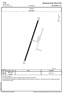
ADC chart of 1L8
 Satellite view of 1L8
Satellite view of 1L8
Sorry, we have no imagery here.
Sorry, we have no imagery here.
Sorry, we have no imagery here.
Sorry, we have no imagery here.
Sorry, we have no imagery here.
Sorry, we have no imagery here.


1L8 - General Dick Stout Fld
Located in Hurricane, United States
ICAO - 1L8, IATA -
Data provided by AirmateGeneral information
Coordinates: N37°8'25" W113°18'22"
Elevation is 3351 feet MSL.
Magnetic variation is 14° East View others Airports in Utah
Operational data
Special qualification required
Current time UTC:
Current local time:
Weather at : KSGU - St George Rgnl ( 21 km )
METAR: KSGU 312056Z AUTO 26008KT 220V280 10SM CLR 21/M02 A2982 RMK AO2 SLP078 T02061022 56026
TAF: KSGU 311733Z 3118/0118 25010G18KT P6SM SCT200 FM312200 23022G35KT P6SM SCT150 FM010000 23028G42KT P6SM SCT150 FM010700 26017G25KT P6SM SCT100 FM011200 28009KT P6SM SCT200
Communications frequencies: [VIEW]
Runways:
| RWY identifier | QFU | Length (ft) | Width (ft) | Surface | LDA (ft) |
| 01 | 18° | 3282 | 60 | ASPH | |
| 19 | 198° | 3282 | 60 | ASPH |
Airport contact information
Address: Hurricane United States
Satellite view of 1L8
Sorry, we have no imagery here.
Sorry, we have no imagery here.
Sorry, we have no imagery here.
Sorry, we have no imagery here.
Sorry, we have no imagery here.
Sorry, we have no imagery here.