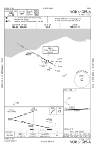
IAC chart of 1G1
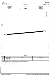
 ADC chart of 1G1
 Satellite view of 1G1
ADC chart of 1G1
Satellite view of 1G1
Sorry, we have no imagery here.
Sorry, we have no imagery here.
Sorry, we have no imagery here.
Sorry, we have no imagery here.
Sorry, we have no imagery here.
Sorry, we have no imagery here.


1G1 - Elyria
Located in Elyria, United States
ICAO - 1G1, IATA -
Data provided by AirmateGeneral information
Coordinates: N41°19'54" W82°6'1"
Elevation is 758 feet MSL.
Magnetic variation is -06° East View others Airports in Ohio
Operational data
Special qualification required
Current time UTC:
Current local time:
Weather at : KLPR - Lorain County Rgnl ( 7 km )
METAR: KLPR 061853Z AUTO 03006KT 10SM OVC085 03/M04 A3004 RMK AO2 SLP178 T00281039 PWINO
Communications frequencies: [VIEW]
Runways:
| RWY identifier | QFU | Length (ft) | Width (ft) | Surface | LDA (ft) |
| 09 | 85° | 3053 | 48 | ASPH | |
| 27 | 265° | 3053 | 48 | ASPH |
Airport contact information
Address: Elyria United States
Satellite view of 1G1
Sorry, we have no imagery here.
Sorry, we have no imagery here.
Sorry, we have no imagery here.
Sorry, we have no imagery here.
Sorry, we have no imagery here.
Sorry, we have no imagery here.