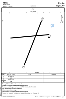
ADC chart of 18NV
 Satellite view of 18NV
Satellite view of 18NV
Sorry, we have no imagery here.
Sorry, we have no imagery here.
Sorry, we have no imagery here.
Sorry, we have no imagery here.
Sorry, we have no imagery here.
Sorry, we have no imagery here.


18NV - Empire
Located in Empire, United States
ICAO - 18NV, IATA -
Data provided by AirmateGeneral information
Coordinates: N40°34'43" W119°21'5"
Elevation is 3990 feet MSL.
Magnetic variation is 17° East View others Airports in Nevada
Operational data
Special qualification required
Current time UTC:
Current local time:
Weather at : - ( 0 km )
METAR: TXKF 050655Z 28012KT 9999 SCT010 SCT300 20/19 Q1024
Communications frequencies: [VIEW]
Runways:
| RWY identifier | QFU | Length (ft) | Width (ft) | Surface | LDA (ft) |
| 07 | 0° | 3170 | 48 | EARTH | |
| 25 | 0° | 3170 | 48 | EARTH | |
| 18 | 202° | 3770 | 42 | EARTH | |
| 36 | 22° | 3770 | 42 | EARTH |
Airport contact information
Address: Empire United States
Satellite view of 18NV
Sorry, we have no imagery here.
Sorry, we have no imagery here.
Sorry, we have no imagery here.
Sorry, we have no imagery here.
Sorry, we have no imagery here.
Sorry, we have no imagery here.