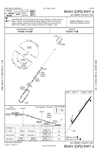
IAC chart of 18I
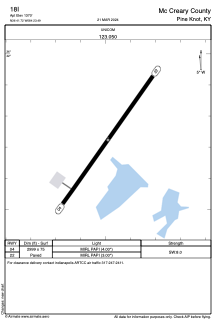
 ADC chart of 18I
 Satellite view of 18I
ADC chart of 18I
Satellite view of 18I
Sorry, we have no imagery here.
Sorry, we have no imagery here.
Sorry, we have no imagery here.
Sorry, we have no imagery here.
Sorry, we have no imagery here.
Sorry, we have no imagery here.


18I - Mc Creary County
Located in Pine Knot, United States
ICAO - 18I, IATA -
Data provided by AirmateGeneral information
Coordinates: N36°41'43" W84°23'29"
Elevation is 1371 feet MSL.
Magnetic variation is -05° East View others Airports in Kentucky
Operational data
Special qualification required
Current time UTC:
Current local time:
Weather at : KBYL - Williamsburg-Whitley County ( 20 km )
METAR: KBYL 020355Z AUTO 14004KT 10SM CLR 12/04 A3003 RMK AO1
Communications frequencies: [VIEW]
Runways:
| RWY identifier | QFU | Length (ft) | Width (ft) | Surface | LDA (ft) |
| 04 | 35° | 2999 | 75 | ASPH | |
| 22 | 215° | 2999 | 75 | ASPH |
Airport contact information
Address: Pine Knot United States
Satellite view of 18I
Sorry, we have no imagery here.
Sorry, we have no imagery here.
Sorry, we have no imagery here.
Sorry, we have no imagery here.
Sorry, we have no imagery here.
Sorry, we have no imagery here.