ADC chart of 17A
 Satellite view of 17A
Satellite view of 17A
Sorry, we have no imagery here.
Sorry, we have no imagery here.
Sorry, we have no imagery here.
Sorry, we have no imagery here.
Sorry, we have no imagery here.
Sorry, we have no imagery here.


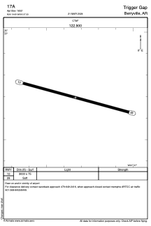
17A - Trigger Gap
Located in Berryville, United States
ICAO - 17A, IATA -
Data provided by AirmateGeneral information
Coordinates: N36°19'42" W93°37'20"
Elevation is 1650 feet MSL.
View others Airports in Arkansas
Operational data
Special qualification required
Current time UTC:
Current local time:
Weather at : KHRO - Boone County ( 43 km )
METAR: KHRO 050653Z AUTO 30007KT 2 1/2SM -RA BR BKN005 OVC009 09/08 A2998 RMK AO2 LTG DSNT E-SW RAB44 SLP148 P0001 T00940083
TAF: KHRO 050521Z 0506/0606 33009KT P6SM -RA VCTS BKN003 OVC020CB FM050900 04007KT 6SM SHRA BR OVC003 FM051400 36010G21KT 3SM +SHRA BR OVC003 FM052100 02012G25KT 4SM SHRA BR OVC008 FM060300 01016G22KT 4SM -RA BR OVC003
Communications frequencies: [VIEW]
Runways:
| RWY identifier | QFU | Length (ft) | Width (ft) | Surface | LDA (ft) |
| 10 | 105° | 3000 | 75 | GRASS | |
| 28 | 285° | 3000 | 75 | GRASS |
Airport contact information
Address: Berryville United States
Satellite view of 17A
Sorry, we have no imagery here.
Sorry, we have no imagery here.
Sorry, we have no imagery here.
Sorry, we have no imagery here.
Sorry, we have no imagery here.
Sorry, we have no imagery here.