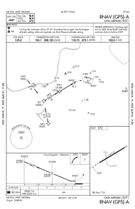
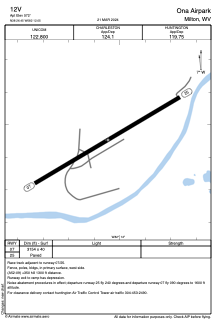
12V - Ona Airpark
Located in Milton, United States
ICAO - 12V, IATA -
Data provided by AirmateGeneral information
Coordinates: N38°26'27" W82°12'3"
Elevation is 572 feet MSL.
Magnetic variation is -06° East View others Airports in West Virginia
Operational data
Special qualification required
Current time UTC:
Current local time:
Weather at : KHTS - Tri-State/Milton J Ferguson Fld ( 32 km )
METAR: KHTS 030909Z 24010G17KT 4SM VCTS RA BR BKN036 BKN070 OVC090 18/16 A2999 RMK AO2 PK WND 26034/0852 LTG DSNT ALQDS TSE09 P0026 T01830161 $
TAF: KHTS 030538Z 0306/0406 18011G23KT P6SM OVC220 FM030800 28014G30KT 1SM -TSRA BR OVC015CB FM030900 21012G24KT 4SM -RA BR VCTS OVC060CB FM031100 23011G23KT P6SM VCSH OVC060 FM031700 27007KT 4SM -TSRA OVC025CB FM032000 27006KT P6SM OVC015 TEMPO 0320/0323 3SM TSRA BR BKN012CB FM032300 VRB04KT P6SM OVC012 FM040300 05004KT 4SM BR BKN011
Communications frequencies: [VIEW]
Runways:
| RWY identifier | QFU | Length (ft) | Width (ft) | Surface | LDA (ft) |
| 07 | 59° | 3154 | 40 | ASPH | |
| 25 | 239° | 3154 | 40 | ASPH |
Airport contact information
Address: Milton United States
Other aviation service providers
Flight schools
Satellite view of 12V
Sorry, we have no imagery here.
Sorry, we have no imagery here.
Sorry, we have no imagery here.
Sorry, we have no imagery here.
Sorry, we have no imagery here.


