ADC chart of 12S
 Satellite view of 12S
Satellite view of 12S
Sorry, we have no imagery here.
Sorry, we have no imagery here.
Sorry, we have no imagery here.
Sorry, we have no imagery here.
Sorry, we have no imagery here.
Sorry, we have no imagery here.


12S - Monument Muni
Located in Monument, United States
ICAO - 12S, IATA -
Data provided by AirmateGeneral information
Coordinates: N44°49'54" W119°25'47"
Elevation is 2323 feet MSL.
Magnetic variation is 18° East View others Airports in Oregon
Operational data
Special qualification required
Current time UTC:
Current local time:
Weather at : KGCD - Grant County Rgnl/Ogilvie Fld ( 60 km )
METAR: KGCD 022055Z AUTO 25005KT 10SM CLR 29/07 A3022 RMK AO2 LTG DSNT S T02910065
Communications frequencies: [VIEW]
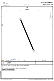
Runways:
| RWY identifier | QFU | Length (ft) | Width (ft) | Surface | LDA (ft) |
| 14 | 157° | 2104 | 29 | ASPH | |
| 32 | 337° | 2104 | 29 | ASPH |
Airport contact information
Address: Monument United States
Satellite view of 12S
Sorry, we have no imagery here.
Sorry, we have no imagery here.
Sorry, we have no imagery here.
Sorry, we have no imagery here.
Sorry, we have no imagery here.
Sorry, we have no imagery here.