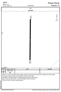
ADC chart of 10TT
 Satellite view of 10TT
Satellite view of 10TT
Sorry, we have no imagery here.
Sorry, we have no imagery here.
Sorry, we have no imagery here.
Sorry, we have no imagery here.
Sorry, we have no imagery here.
Sorry, we have no imagery here.


10TT - Rosser Ranch
Located in Graham, United States
ICAO - 10TT, IATA -
Data provided by AirmateGeneral information
Coordinates: N33°0'54" W98°37'34"
Elevation is 1112 feet MSL.
Magnetic variation is 07° East View others Airports in Texas
Operational data
Special qualification required
Current time UTC:
Current local time:
Weather at : KRPH - Graham Muni ( 13 km )
METAR: KRPH 020415Z AUTO 16012G20KT 8SM CLR 25/20 A2941 RMK AO2 T02490201
Communications frequencies: [VIEW]
Runways:
| RWY identifier | QFU | Length (ft) | Width (ft) | Surface | LDA (ft) |
| 18 | 181° | 3600 | 200 | GRASS | |
| 36 | 1° | 3600 | 200 | GRASS |
Airport contact information
Address: Graham United States
Satellite view of 10TT
Sorry, we have no imagery here.
Sorry, we have no imagery here.
Sorry, we have no imagery here.
Sorry, we have no imagery here.
Sorry, we have no imagery here.
Sorry, we have no imagery here.