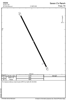
ADC chart of 0XA4
 Satellite view of 0XA4
Satellite view of 0XA4
Sorry, we have no imagery here.
Sorry, we have no imagery here.
Sorry, we have no imagery here.
Sorry, we have no imagery here.
Sorry, we have no imagery here.
Sorry, we have no imagery here.


0XA4 - Seven C's Ranch
Located in Freer, United States
ICAO - 0XA4, IATA -
Data provided by AirmateGeneral information
Coordinates: N27°59'50" W98°52'58"
Elevation is 336 feet MSL.
Magnetic variation is 05° East View others Airports in Texas
Operational data
Special qualification required
Current time UTC:
Current local time:
Weather at : KCOT - Cotulla-La Salle County ( 61 km )
METAR: KCOT 012053Z AUTO 17012G21KT 8SM FEW047 34/21 A2957 RMK AO2 PK WND 15026/2020 SLP006 T03390206 56049
TAF: KCOT 011739Z 0118/0218 16012G20KT P6SM BKN035 FM020300 14019G26KT P6SM SCT250 FM020600 15012G20KT P6SM BKN250 WS020/18045KT FM021200 13008KT P6SM FEW025 BKN250
Communications frequencies: [VIEW]
Runways:
| RWY identifier | QFU | Length (ft) | Width (ft) | Surface | LDA (ft) |
| 15 | 0° | 5005 | 75 | ASPH | |
| 33 | 0° | 5005 | 75 | ASPH |
Airport contact information
Address: Freer United States
Satellite view of 0XA4
Sorry, we have no imagery here.
Sorry, we have no imagery here.
Sorry, we have no imagery here.
Sorry, we have no imagery here.
Sorry, we have no imagery here.
Sorry, we have no imagery here.