IAC chart of 0M4
 ADC chart of 0M4
 Satellite view of 0M4
ADC chart of 0M4
Satellite view of 0M4
Sorry, we have no imagery here.
Sorry, we have no imagery here.
Sorry, we have no imagery here.
Sorry, we have no imagery here.
Sorry, we have no imagery here.
Sorry, we have no imagery here.


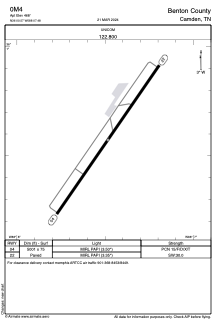
0M4 - Benton County
Located in Camden, United States
ICAO - 0M4, IATA -
Data provided by AirmateGeneral information
Coordinates: N36°0'34" W88°7'29"
Elevation is 468 feet MSL.
Magnetic variation is -02° East View others Airports in Tennessee
Operational data
Special qualification required
Current time UTC:
Current local time:
Weather at : KHZD - Carroll County ( 32 km )
METAR: KHZD 061230Z AUTO 03006KT 1 1/4SM BR OVC005 09/09 A2992 RMK A01
Communications frequencies: [VIEW]
Runways:
| RWY identifier | QFU | Length (ft) | Width (ft) | Surface | LDA (ft) |
| 04 | 35° | 5001 | 75 | ASPH | |
| 22 | 215° | 5001 | 75 | ASPH |
Airport contact information
Address: Camden United States
Satellite view of 0M4
Sorry, we have no imagery here.
Sorry, we have no imagery here.
Sorry, we have no imagery here.
Sorry, we have no imagery here.
Sorry, we have no imagery here.
Sorry, we have no imagery here.