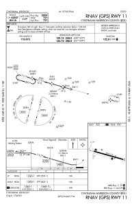
IAC chart of 0I8
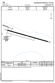
 ADC chart of 0I8
 Satellite view of 0I8
ADC chart of 0I8
Satellite view of 0I8
Sorry, we have no imagery here.
Sorry, we have no imagery here.
Sorry, we have no imagery here.
Sorry, we have no imagery here.
Sorry, we have no imagery here.
Sorry, we have no imagery here.


0I8 - Cynthiana-Harrison County
Located in Cynthiana, United States
ICAO - 0I8, IATA -
Data provided by AirmateGeneral information
Coordinates: N38°21'58" W84°17'0"
Elevation is 721 feet MSL.
Magnetic variation is -06° East View others Airports in Kentucky
Operational data
Special qualification required
Current time UTC:
Current local time:
Weather at : KIOB - Mount Sterling/Montgomery County ( 43 km )
METAR: KIOB 020235Z AUTO 00000KT 10SM CLR 08/02 A3008 RMK AO2 PWINO
Communications frequencies: [VIEW]
Runways:
| RWY identifier | QFU | Length (ft) | Width (ft) | Surface | LDA (ft) |
| 11 | 106° | 3850 | 75 | ASPH | 3852 |
| 29 | 286° | 3850 | 75 | ASPH | 2757 |
Airport contact information
Address: Cynthiana United States
Satellite view of 0I8
Sorry, we have no imagery here.
Sorry, we have no imagery here.
Sorry, we have no imagery here.
Sorry, we have no imagery here.
Sorry, we have no imagery here.
Sorry, we have no imagery here.