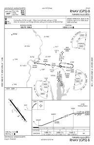
IAC chart of 0B5
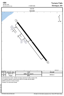
 ADC chart of 0B5
 Satellite view of 0B5
ADC chart of 0B5
Satellite view of 0B5
Sorry, we have no imagery here.
Sorry, we have no imagery here.
Sorry, we have no imagery here.
Sorry, we have no imagery here.
Sorry, we have no imagery here.
Sorry, we have no imagery here.


0B5 - Turners Falls
Located in Montague, United States
ICAO - 0B5, IATA -
Data provided by AirmateGeneral information
Coordinates: N42°35'30" W72°31'23"
Elevation is 359 feet MSL.
Magnetic variation is -15° East View others Airports in Massachusetts
Operational data
Special qualification required
Current time UTC:
Current local time:
Weather at : KORE - Orange Muni ( 19 km )
METAR: KORE 312203Z AUTO 19010KT 10SM SCT016 16/13 A2959 RMK AO2 T01610133
Communications frequencies: [VIEW]
Runways:
| RWY identifier | QFU | Length (ft) | Width (ft) | Surface | LDA (ft) |
| 16 | 143° | 3200 | 75 | ASPH | |
| 34 | 323° | 3200 | 75 | ASPH |
Airport contact information
Address: Montague United States
Other aviation service providers
Flight schools

Satellite view of 0B5
Sorry, we have no imagery here.
Sorry, we have no imagery here.
Sorry, we have no imagery here.
Sorry, we have no imagery here.
Sorry, we have no imagery here.
Sorry, we have no imagery here.