ADC chart of 00IG
 Satellite view of 00IG
Satellite view of 00IG
Sorry, we have no imagery here.
Sorry, we have no imagery here.
Sorry, we have no imagery here.
Sorry, we have no imagery here.
Sorry, we have no imagery here.
Sorry, we have no imagery here.


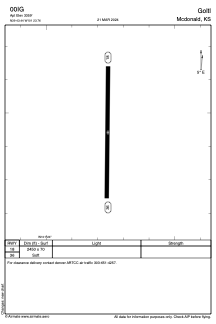
00IG - Goltl
Located in Mcdonald, United States
ICAO - 00IG, IATA -
Data provided by AirmateGeneral information
Coordinates: N39°43'27" W101°23'46"
Elevation is 3359 feet MSL.
View others Airports in Kansas
Operational data
Special qualification required
Current time UTC:
Current local time:
Weather at : KSYF - Cheyenne County Muni ( 34 km )
METAR: KSYF 111735Z AUTO 18018G24KT 10SM CLR 22/M00 A3021 RMK AO2
Communications frequencies: [VIEW]
Runways:
| RWY identifier | QFU | Length (ft) | Width (ft) | Surface | LDA (ft) |
| 18 | 0° | 2450 | 70 | GRASS | |
| 36 | 0° | 2450 | 70 | GRASS |
Airport contact information
Address: Mcdonald United States
Satellite view of 00IG
Sorry, we have no imagery here.
Sorry, we have no imagery here.
Sorry, we have no imagery here.
Sorry, we have no imagery here.
Sorry, we have no imagery here.
Sorry, we have no imagery here.