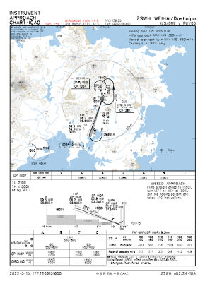
IAC chart of ZSWH
 Satellite view of ZSWH

Satellite view of ZSWH
Sorry, we have no imagery here.
Sorry, we have no imagery here.
Sorry, we have no imagery here.
Sorry, we have no imagery here.
Sorry, we have no imagery here.
Sorry, we have no imagery here.


ZSWH - Weihai/Dashuipo
Located in Weihai, China
ICAO - ZSWH, IATA - WEH
Data provided by AirmateGeneral information
Coordinates: N37°11'18" E122°13'48"
Elevation is 148 feet MSL.
View others Airports in Shandong Province
Operational data
Special qualification required
Current time UTC: 02:43:41
Current local time:
Weather at : - ( 0 km )
METAR: UNEE 280242Z 13003MPS 8000 -SHSNRA BKN004 OVC029CB 01/01 Q1011 R23/290155 NOSIG RMK QFE735
Communications frequencies: [VIEW]
Runways:
| RWY identifier | QFU | Length (ft) | Width (ft) | Surface | LDA (ft) |
| 03 | 18° | 8530 | 148 | UNK | |
| 21 | 198° | 8530 | 148 | UNK |
Airport contact information
Address: Weihai China
Satellite view of ZSWH
Sorry, we have no imagery here.
Sorry, we have no imagery here.
Sorry, we have no imagery here.
Sorry, we have no imagery here.
Sorry, we have no imagery here.
Sorry, we have no imagery here.